|
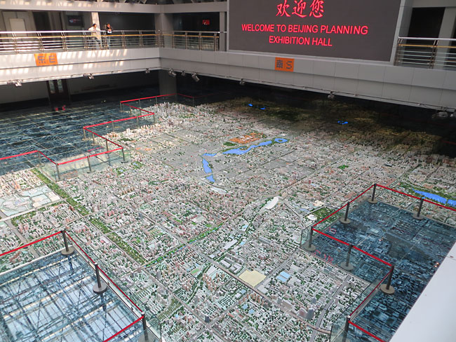
The Beijing Planning Exhibition Hall opened in 2004 and features four floors of museum exhibits about the history of China's capital city and its projected growth in the next 20 years.
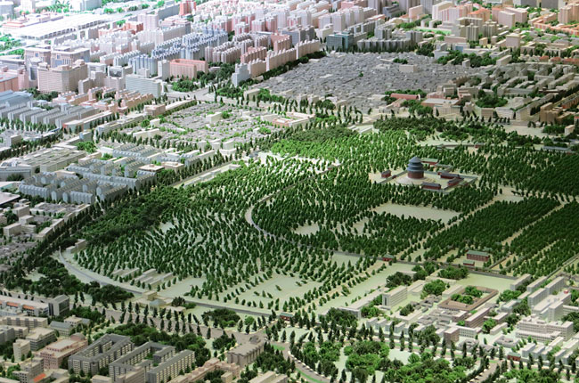
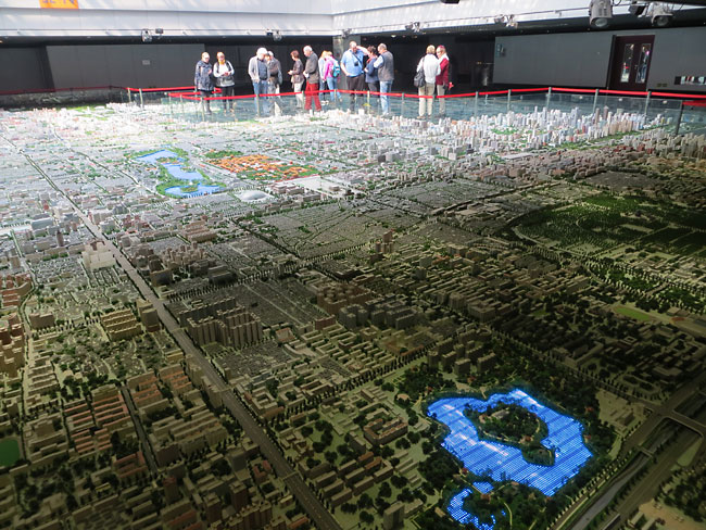
The centerpiece of the museum is a sprawling 1:750 scale city model constructed by a team of 150 craftsmen in a year. The model shows in dramatic 3D the master plan of Beijing. That is, the model depicts the city as it is imagined to be in 2020 when current developments are completed, not the city of the present. The model depicts a blocky central area of the city about 10 miles across (70 scale feet), from the Temple of Heaven in the south to the Olympic Park in the north and from the CBD in the east to the China Central Television Tower in the west, rather than a square section or the complete boundaries of the city. Perhaps the neighborhoods not included may feel slighted, but the jagged outline gives viewers a few places to step forward to get a closer look at the center of the model.
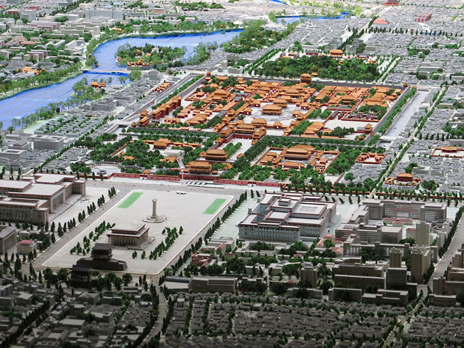
Beijing is located on a flat plain in a readily-apparent rectangular grid. The layout of the city dates to 1271 when Kublai Khan established his capital Dadu here. The city was planned according to feng shui principles, on an axis protected by mountains to the north and open to the sun toward the south. At the center of the Beijing Planning Model the square of the now-demolished Ming-dynasty city walls can be discerned by the grey rooftops of sprawling hutong neighborhoods. Within that is the square wall of the Forbidden City which is easily spotted in the photo above by its orange rooftops. To the south of the Forbidden City lies the vast plaza of Tiananmen Square with Mao's Mausoleum and the pillar of the Monument to the People's Heroes.
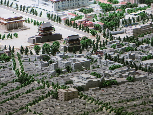
Continuing south, the tall Qianmen or Zhengyangmen tower and smaller archery tower in the photo above were once the primary gate into the old city wall which was torn down in the 1960s for construction of the Beijing subway. A tiny red gate is visible farther south of the archery tower which marks the head of Qianmen shopping street. In the near distance, the rooftops of tiny hutong neighborhood houses are visible. The Beijing Planning Exhibition Hall which houses the city model is the larger boxy building on the right of the photo close to the top.
The rows of tiny trees in the Temple of Heaven park are pretty spectacular, though perhaps some visitor dropped a hat or newspaper on a few of them, leaving the forest tilted as if by a windstorm.
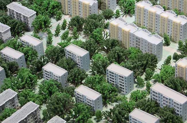
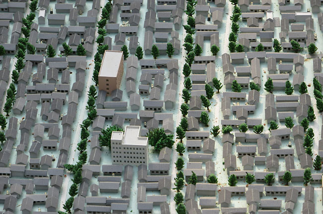
While the parks of Beijing do have a lot of trees, I'm not convinced that this neighborhood of high-rise apartments is this green in reality. The Beijing city model is certainly more true-to-life than the Shanghai city model, but this lush canopy seems a bit too much wishful thinking in a region that is more prone to drought and dust storms than dense forests.
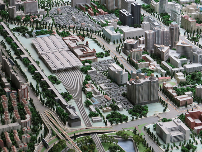
Here's the Beijing Railway Station next to the last remaining section of the old city wall and the southeast guard tower which still stands. Small areas of hutong housing are overlooked by tall hotels and high rises.
In the northeastern part of the city are the Drum tower (left) built in 1272 and Bell tower (right) which signalled the hours in ancient times and were once the heart of Kublai Khan's capital Dadu. West of the towers is Houhai with its many lakeside bars and restaurants, with blue LEDs to show the rippling waters of the lake.
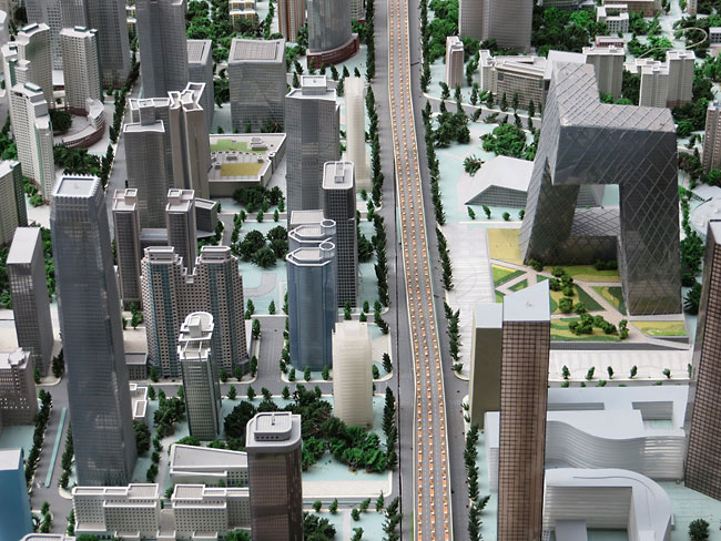
On the far east edge of the model is the Central Business District, which was mostly unbuilt when the model was first opened in 2004. Beijing's tallest skyscraper, the China World Trade Center Tower III (left) was finished in 2010. The China Central Television headquarters (right) designed by Rem Koolhaas was completed in 2008. The rest of the smaller skyscrapers may or may not be finished at this time, as the model represents not present reality but the neighborhood in 2020, as imagined in 2004. (A smaller 1:750 scale model on display nearby seems to be more recently updated and depicts the CBD with new structures currently under construction, such as the 1,673-foot supertall China Zun skyscraper.) The yellow lines on the elevated roadway are not taxi cabs but simply rows of LEDs to highlight the elevated expressways of the city, similar to the LEDs highlighting the Shanghai city model.
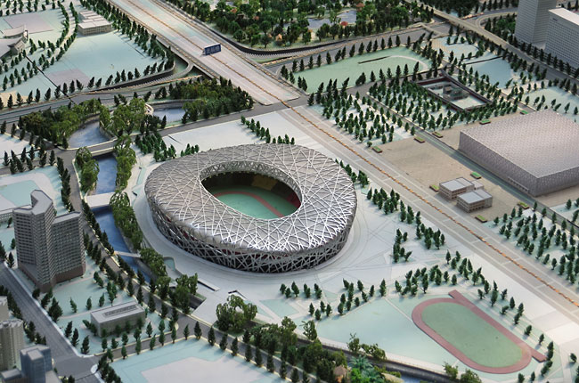
Publicity and marketing for the 2008 Olympics were an important function of the city model when it opened in 2004, similar to the Pipers London model from 2008. The Birds Nest stadium and Water Cube aquatics center are at the north edge of the model, with the road in the center in line with the north-south axis through the Forbidden City to Tiananmen Square seen in the second and third photos at the top of the page.
The low sprawl of hutong housing in various parts of the city is not depicted with much detail. Are there really so many trees planted along these small streets? While the traditional alleys and courtyard houses were built by a rough pattern to orient toward the southern sunlight, the clusters of tiny buildings on the model seem arbitrary and probably do not correspond with the real structures on the ground. Elsewhere in the museum there are excellent exhibits which explain in great detail Beijing's unique development of narrow hutong alleys and siheyuan courtyard houses which cluster around a shared well, so its a shame that the large city model is so imprecise in detail in these areas. The urban planners of Beijing have been much criticized by historic preservationists for demolishing as much as 70% of the old-style hutong neighborhoods of the city in the last 20 years. Perhaps the generic buildings of the model show a lack of appreciation for these areas.
The real Beijing outside is often plagued with haze and thick smog of air pollution, but the perfectly planned mini Beijing of 2020 always enjoys clear sunny skies. Even the supertall skyscrapers of the CBD cannot provide an overview of the city quite like overlooking the model city.
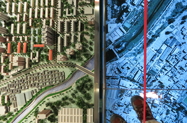
Outside the boundaries of the model, the city continues on in same-scale aerial photos under the glass floor of the exhibit hall. Here the three dimensions are flattened into two, and the shiny future of perfectly-planned Beijing becomes the messy present reality of a photograph. Its fascinating to see roadways and rivers continue across the transition line. Visitors should take warning that the glass floors generate a lot of static electricity, which will zap you if you come near the railing around the model!
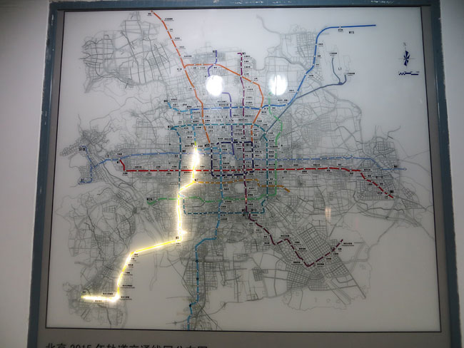
While the city model is the centerpiece of the Planning Exhibition Hall, there are many other interesting exhibits in the museum about the growth of the city in the past and future. Here a display spotlights a new subway line, part of the rapid expansion since 2002 of what is now the world's third-busiest subway system. There is also a small theater and interactive 3D games to help explain urban planning techniques and videos explaining how displaced residents of redeveloped areas are adjusting well to their new homes.
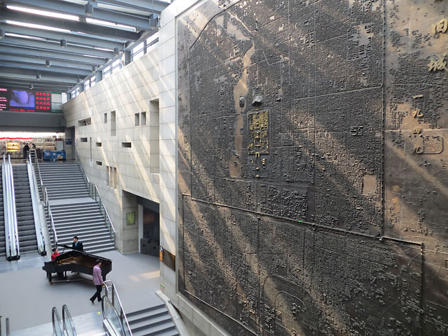
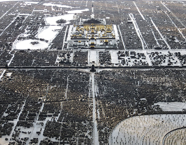
The other spectacular exhibit at the museum is a 1:1000 scale model cast in bronze of Beijing as it appeared at the end of the revolution in 1949, as reconstructed from historic maps. The model is roughly 30 feet high and is mounted sideways in the museum's central staircase.
Its a bit difficult to see the bronze model from any angle other than the staircase below or the balcony opposite, but the effect of the monochrome bronze is magical, like looking at a black & white aerial photo of Beijing. The only coloration of the model is the gold rooftops of the Forbidden City.
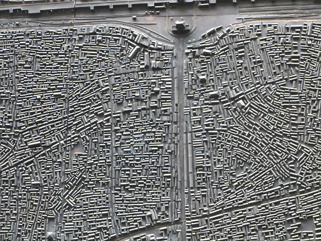
Here is the archery tower gatehouse at the head of Qianmen shopping street in 1949. Compare the tiny crowded alleys and houses to the same area on the large model shown in the third photo at the top of the page. Visit other mini cities around the world |