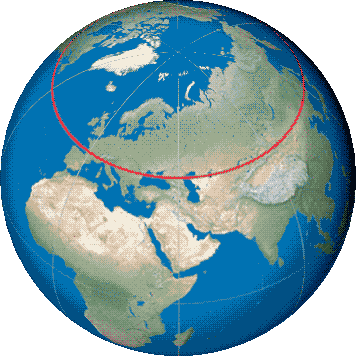
an imaginary line circles the earth.
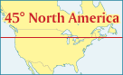
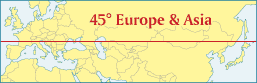
If you stand on this line, you may not realize that the same latitude connects the mountains of Yellowstone and the piney woods of Maine to the wine regions of Bordeaux, the Crimean peninsula, the Gobi Desert of Mongolia, and the snowy northern tip of Hokkaido, Japan. What do these disparate regions of the earth have in common? Only that every day the sun will shine down on each place at exactly the same angle. Sun-seekers living in Lincoln City, Oregon and Minneapolis, Minnesota can take comfort knowing that the residents of Turin, Italy receive exactly the same length of daylight on the other side of the earth.
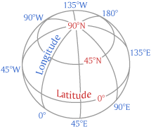
Geographers divide the earth into lines of latitude which run east-west on planes parallel to the equator, and lines of longitude which run north-south converging at the poles. Latitude is measured in degrees north or south from 0 degrees at the equator to 90 degrees at the poles, while longitude is measured in degrees east or west from the arbitrary 0-degree Prime Meridian at Greenwich, England.
Latitude can be defined in several ways. Geocentric latitude measures the angle from the plane of the equator at the center of the earth to a point on the surface, which is what many people assume is marked by the 45th Parallel. However, surveyors and geographers measure the geodetic latitude, or the angle of a vertical "normal" line from a point on the earth's surface to the plane of the equator. In the old days this was done by measuring the angle of the noonday sun, or a star such as the north star Polaris, in relation to a precisely horizontal level or a perfectly vertical plumb line.
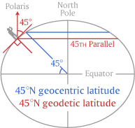
Because the earth's rotation causes the planet to bulge slightly at the equator and flatten at the poles, it is distorted into an ellipsoid or oblate spheroid. The Earth's diameter at the equator is about 7926 miles / 12,756 km while its polar diameter is about 7900 miles / 12,713 km, meaning that the radius at the Equator bulges about 13 miles / 21 km farther from the center than at the poles (much exaggerated in the stylized cross-section diagram above). The flattened shape means that the geocentric latitude and geodetic latitude angles deviate increasingly between the equator and the poles. At the 45th Parallel, the two latitudes are a maximum of 11.5' or about 13 miles / 21 km apart.
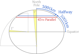
Many monuments and signs on the 45th Parallel declare that the latitude is "Halfway between the North Pole and the Equator", but again this is not precisely true due to the distortion caused by the Earth's rotation. At the higher latitudes near the poles where the Earth is slightly flatter, the curvature of the surface can be described by an arc of larger radius, and therefore each degree of latitude is larger and slightly longer (about 69.4 miles / 111.7 km at 89°). This is much exaggerated in the diagram above. Near the Equator where the curvature is tighter, the surface is described by an arc of smaller radius and therefore slightly shorter length (about 68.7 miles / 110.5 km at 1°).
Since the 45 degrees north of the Parallel are longer than those south of it, this shifts the Parallel south of the Halfway line. The line equidistant between the North Pole and the Equator is at about 45° 8.65' or almost 10 miles / 16 km north of the 45th Parallel. In eastern Wisconsin, a series of monuments commemorate the divergent locations of the 45th Parallel as well as the Halfway line.
Outside of the U.S., the Halfway line can be rounded to a satisfyingly round number of 5000 kilometers in each direction. In 1791 the French Academy of Sciences defined the length of a meter to be one 10-millionth of the distance between the Equator and North Pole. But first a survey expedition needed to calculate and measure that unknown distance. Errors in the survey and limitations of the available technology underestimated the distance slightly, which was incorporated into the official length of the meter, so that nowadays we know it is 10,001.9 kilometers from the Equator to the North Pole rather than the decimally perfect figure intended. Within the U.S., the Halfway line is simply a sloppy 3107.5 miles away from each extreme.
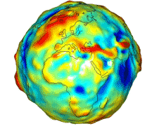
Geometrically the Earth can be described in a simplified way as an ellipsoid or oblate spheroid, but the actual shape of the planet is more irregular due to the uneven distribution of mass within the core, and therefore uneven gravity across its surface. The geoid is the theoretical shape of the globe (shown in a Wikipedia graphic above) as if all topography of continents, mountains and valleys were removed, leaving only a spinning blob of lumpy mass and uneven gravity.
In the 1950s and 60s the U.S. Department of Defense began developing a more precise geodetic system to guide ICBM warheads, which evolved by stages into the World Geodetic System (WGS84) that provides the reference data allowing GPS receivers to pinpoint their location. The lines of latitude and longitude used by GPS are based on a mathematical model of the earth rather than surface observations which are affected by irregularities of local gravity. Indeed the original Prime Meridian itself no longer passes through the Greenwich Observatory which once defined all other longitudes, due to these space-based calculations. Nowadays is easy enough to find your position anywhere on the globe using a smart phone or GPS, but harder to remember that these numbers are based on complex mathematical models (using different models or datum in different hemispheres) and not precisely the same as your actual physical location on Earth.
Perhaps as an antidote to our casual reliance on GPS maps and the hidden complexities of their geodetic calculations, it is enjoyable to see simple non-electronic signs and markers which tell us our place on the earth. Residents of the northern hemisphere are blessed with many places to experience the imaginary 45th Parallel in person, while those in the southern side of the globe must make due with only two small places where 45° South can be seen on dry land. The southern parallel crosses New Zealand briefly before continuing its lonely journey across the sea, bypassing Africa entirely, making landfall for a brief traverse across windswept Patagonia in South America before heading out across the South Pacific.
There is nothing particularly special about the 45th Parallel except as a geographic curiosity. The 40th and 50th Parallels have also inspired weighty commemorations. But to many people who live along the 45th all around the world, its location halfway between the pole and the equator represents more. In an intemperate world, here is the most temperate place in the temperate zone. It is an idealized midpoint between extremes of cold and heat, the sweet spot between the Apollonian rationality of the frigid north and the Dionysian turbulence of the torrid zone of the south. This pride in "middleness" may be strongest in the mid-continent regions the 45th traverses, in North America as well as in Europe, where residents seek a cultural midpoint distinct from the dominance of the coastal fringes, and the moody swings of continental weather are a seasonal reminder of the possibilities of extremes. As with anywhere, homeland pride can inspire both parochial isolationism as well as a sympathetic global point of view.
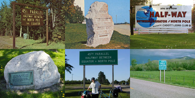
The 45th Parallel is an abstract idea, but in many places devotees of the intagible world of latitudes and longitudes have made it visible with physical markers. Here and there in small towns and along country highways the 45° traveller will find simple road signs and elaborate stone monuments alerting all passersby to think about how these particular places are connected to the rest of the globe, and by extension to our place in the entire cosmos. Click on the maps below to see 45th Parallel markers around the world.