« January 2008 | Main | April 2008 »

February 2008 Archives

February 13, 2008

End of the Mississippi

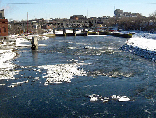
The Mississippi carries the most trade of any river in the world. I am most familiar with the upper reaches of the big river in Minnesota and Wisconsin, where barges are common enough. But after seeing the traffic on the river between New Orleans and Baton Rouge I now understand what it means to say that the Mississippi is the busiest river in the world.

P2038396

Outside Baton Rouge the barges were lined up by dozens, with towboats idling and waiting for a signal to head out to some depot rendezvous. Some of the tows were moving up or down, but most were just parked along the banks, forming nearly a solid line for miles. In some places on the upper river there are hundreds of barges tied up along the banks, but these here were all in active service and ready to move.

P2038404

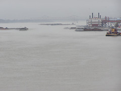
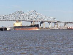
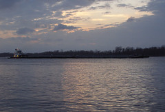
Perhaps there is some lower river traffic service that coordinates which tows should head up or down in midstream. Because, even as large as the barges are, there are even bigger boats at play in the river down here.

Upriver

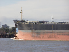
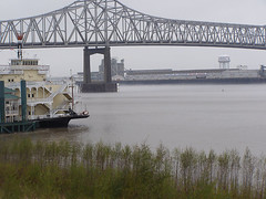
Enormous ocean-going vessels charged upstream at furious speeds, even against the strong river current. Definitely not something to get in the way of, even for the big towboats.

P1308212

Long ago the river had been a promenade of sugar plantations lining the banks, each with their Big House in a prominent place fronting the river and rows of slave houses and sugar cane fields stretching back away from the river. The high ground along the levee was a narrow strip of civilization running along both sides of the river where the wealthy built their homes and the poor made due with the swamplands behind.

In antebellum times this area was the wealth and prestige of the Louisiana economy, where sugar barons made their murky fortunes off the exploited and then retired to New Orleans for a life of leisure society.

Oak Alley Plantation

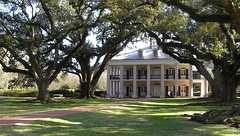
Many of the plantation homes are preserved as museum homes to tell the old history of the area. But the sugar fields remain behind them, scattered with small communities of sharecropper cabins. Nowadays the sugar cane is harvested by machine, an industrial endeavor.

Delta sugar fields

And in places where there had once been plantations there are now enormous industrial complexes. Oil refineries, chemical plants, railroad yards. No one lives in these places, but they provide jobs and money for Louisiana. And the reason they are here is because of the river. Those ocean-going ships and river barges bring in the raw materials and take away the bulk cargo. Oil from the nearby Gulf powers the process, and river water cools the engines and takes away the effluent.

P2038437

The famous engineer James Eads built a set of jetties at the mouth of the Mississippi in 1879, which forced the current of the river to scour the sandbars that had once obstructed traffic entering the river from the sea. It was a boon to New Orleans, and fueled its growth to become the second-busiest port in the US.

But the jetties and the levees built after the great 1927 flood have turned the river from a sprawling delta network of interconnected channels to a narrow conduit of fast moving effluent and trade. The floodwaters that once built the delta land with silt are now directed quickly downstream to keep the flow of boat traffic flowing and wheels of industry humming and the swamplands that protected New Orleans from ocean hurricane surges have been sinking and disappearing since then. Only recently has a plan been released by the Army Corps of Engineers to release some river water again to rebuild the lands around the city.

Standing on the rubbly banks of the river at Baton Rouge, one sees a busy highway of industry, cut off from the network of rich swamplands behind the levees. There is no room here for fishermen or small boats here among the diesel giants, and the water is probably too polluted for much human contact anyway. But the delta is dying without the nourishing waters of this river, and one can only hope that reuniting the bayous and the river will replenish and revitalize both, without smothering all in pollution.

February 16, 2008

Surrounded by Water

The Historic New Orleans Collection, a museum in New Orleans, currently has a fascinating exhibit about the geography of the city and its relationship to waterways. The exhibit and an accompanying film seem to be a plea for understanding of the city and its situation, against critics who question why money should be spent to rebuild and preserve a city in such a precarious place as a sinking swamp.

While it is true that parts of the city are built below sea level, and that the mighty river and sea must be held back by vulnerable levees and sea walls, the location of New Orleans is not some defiance of natural order but a prime location for a city. It was settled as the gateway between the sea and the great Mississippi artery leading in to middle America, back when goods travelled mostly by water. Whether the city can recover an economic reason for its existence other than tourism will be a struggle for the future.

This exhibit provides an excuse for reexamining how the rich history of this place relates to its geography, with the underlying message that New Orleans' future depends on the city becoming a partner with its landscape rather than an adversary.

Surrounded by Water

February 20, 2008

Draining the bathtub

My aunt wrote to me about seeing a 'drawdown' of the Mississippi in Minneapolis today. The Army Corps of Engineers opened the floodgates of the dam just below St. Anthony Falls to drain the pool by 13 feet to inspect the underwater outlet tunnels of Bassett's Creek.

Park service rangers explained the goings on from the Stone Arch Bridge as the water level fell to its lowest in 13 years, exposing the remnants of 19th century bridges and dams and perhaps the ghost of Spirit Island. My cousin Brita was even interviewed on KSTP. MPR has a story too which spotlights some of the industrial archaeology of the oldest part of downtown Minneapolis.

From photos on flickr, its amazing to see the river returning to a somewhat natural free flowing level running across the rocks. Which is very low in winter. Without the big bathtub pool created by the dams, the Mighty Mississippi looks here like a feeble prairie river, hardly the mature river it becomes farther downstream.

February 25, 2008

River Vagrants

Today Charles alerted me to an article in the March Harper's about a guy named Matt who is sailing a homemade boat down the Mississippi. What a silly idea! Who would have thought of that??
You have to be a subscriber to read the article online. I'll have to go get a copy and find out how the tale turns out. Does he make it to New Orleans?

February 27, 2008

Twenty percent

The other day I went to a talk in Rogers Park, part of a new series put on by the 49th Ward Green Corps.

Of the three speakers, I found most interesting the talk by Debra Shore, one of the commissioners of the Metropolitan Water Reclamation District, which manages fresh and wastewater in the greater Chicago area.

Debra Shore

In her talk, Shore said that since the reversal of the Chicago River in 1900, over 30 trillion gallons of Lake Michigan water have been diverted out of its watershed down the Illinois River. There are locks controlling the mouth of the river so most of the drainage does not come directly from the lake, but flows through the piping of the city. Living next to such a huge body of water, most Chicagoans take fresh water for granted. The Great Lakes hold 20% of the fresh water on earth, and 90% of the fresh water in the U.S. so much that it seems unlimited.

But global warming forecasts predict less rainfall in the midwest, and as the Great Lakes states lose population to booming Sun Belt cities, local governments are already planning ahead to a day when outsiders may attempt to exploit our fresh water. Under an agreement by the Council of Great Lakes Governors, no state or province bordering the Lakes is allowed to take water outside of the watershed of the Lakes. But that is exactly what happens in Chicago. Over 900 million gallons of fresh water are pulled in each day from Lake Michigan, are used by citizens, then flow through treatment plants to end up the Chicago River and drain out of the natural watershed. Even rainwater which falls on the city runs into storm drains which connect to the sewage system, or stored in the Deep Tunnel and eventually pumped to the same treatment plants and sent away.

At this point there are no plans to reverse the flow of wastewater flowing south out of the city, but there are many things that can be done to reduce the amount of water that needs to be taken from the lake, and the Water Reclamation District is working on some of these, though without much funding.

M8 million gallons a day are lost from illegal fire hydrant use. Perhaps 78 million gallons a day are lost through leaking pipes. In a city with hundreds of miles of aging, deteriorating water mains, pipe replacement barely keeps up.

Another plan to reduce the amount of water sent downstream is to keep storm and rain water out of the system by green engineering approaches. Bill Eyring of the Center for Neighborhood Technology spoke about rain gardens and bioswales, small garden depressions which can temporarily store runoff from rooftops and parking lots, allowing it to soak into the ground naturally and return to Lake Michigan or the local water table instead of running into the sewage system.

Bill Eyring

Any storm water that can be drained away naturally instead of through the overloaded sewage system also avoids another nasty combined sewage outflow incident like the one we saw up close last summer, when raw sewage floods backwards into the river. And any rain water that that returns to Lake Michigan will help keep the lake as the amazing place it should be.

About February 2008

This page contains all entries posted to Down Chicago’s Drain in February 2008. They are listed from oldest to newest.

January 2008 is the previous archive.

April 2008 is the next archive.

Many more can be found on the main index page or by looking through the archives.

Powered by
Movable Type 3.35